Log in
All resources
Create a design
310 Free Images of 1867 Maps
gemeente atlas van nederland - south holland
1860s maps of south holland
gemeente atlas van nederland - north holland
1860s maps of north holland
géographie illustrée de la france et de ses colonies
media from regionaal archief alkmaar
gemeente atlas van nederland - groningen
orientalist painting
life and work at the great pyramid (1867)
an empire story; stories of india and the greater colonies told to children (1908)
gemeente atlas van nederland - gelderland
maps of ede, netherlands
media from regionaal archief alkmaar
maps of heerhugowaard
gemeente atlas van nederland - south holland
1860s maps of south holland
gemeente atlas van nederland - groningen
maps of slochteren
gemeente atlas van nederland - north brabant
old maps of breda, netherlands
gemeente atlas van nederland - north brabant
maps of baarle-nassau
gemeente atlas van nederland - north brabant
maps of boekel, north brabant
media from regionaal archief alkmaar
maps of barsingerhorn
gemeente atlas van nederland - south holland
1860s maps of south holland
gemeente atlas van nederland - south holland
maps of krimpen aan de lek
media from regionaal archief alkmaar
old maps of schagen
gemeente atlas van nederland - north holland
old maps of amsterdam
gemeente atlas van nederland - groningen
maps of bad nieuweschans
gemeente atlas van nederland - overijssel
old maps of ommen
gemeente atlas van nederland - south holland
giessen (river south-holland)
gemeente atlas van nederland - south holland
giessen (river south-holland)
gemeente atlas van nederland - south holland
1860s maps of south holland
gemeente atlas van nederland - groningen
maps of nieuwe pekela
gemeente atlas van nederland - groningen
maps of oude pekela
gemeente atlas van nederland - groningen
maps of ten boer
gemeente atlas van nederland - groningen
maps of leek, groningen
gemeente atlas van nederland - south holland
maps of zoeterwoude
gemeente atlas van nederland - south holland
19th-century maps of rotterdam
media from regionaal archief alkmaar
oudkarspel
admiralty charts region u: north america east coast
admiralty charts 201-400
gemeente atlas van nederland - south holland
1860s maps of south holland
gemeente atlas van nederland - south holland
1860s maps of south holland
gemeente atlas van nederland - north brabant
maps of loon op zand
gemeente atlas van nederland - south holland
maps of wassenaar
media from regionaal archief alkmaar
maps of barsingerhorn
gemeente atlas van nederland - north holland
old maps of haarlem
gemeente atlas van nederland - gelderland
maps of doorwerth
media from regionaal archief alkmaar
schermerhorn
media from regionaal archief alkmaar
limmen
media from regionaal archief alkmaar
schoorl
gemeente atlas van nederland - gelderland
old maps of wageningen
gemeente atlas van nederland - south holland
1860s maps of south holland
gemeente atlas van nederland - south holland
maps of warmond
gemeente atlas van nederland - south holland
1860s maps of south holland
gemeente atlas van nederland - south holland
1860s maps of south holland
gemeente atlas van nederland - south holland
maps of hazerswoude
gemeente atlas van nederland - south holland
maps of veur
gemeente atlas van nederland - north holland
19th-century maps of den helder
gemeente atlas van nederland - groningen
maps of hoogezand
media from regionaal archief alkmaar
winkel, north holland
gemeente atlas van nederland - south holland
maps of groote lindt
media from regionaal archief alkmaar
egmond-binnen
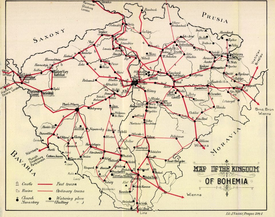
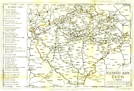
kingdom of bohemia (1867–1918)
20th-century maps of bohemia
maps, prints and photographs in royal danish library
carl wilhelm wiehe
media from regionaal archief alkmaar
zuidschermer
gemeente atlas van nederland - north holland
old maps of beverwijk
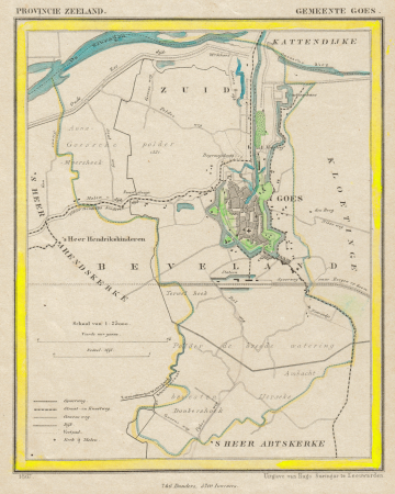
gemeente atlas van nederland - zeeland
old maps of goes
media from regionaal archief alkmaar
zijpe
gemeente atlas van nederland - gelderland
maps of renkum
media from regionaal archief alkmaar
broek op langedijk
maps of uithuizermeeden
oldenzijl
historical
history
eran laor cartographic collection
william hughes (geographer)
masonic temple, boston (boylston street: 1867)
gemeente atlas van nederland - groningen
old maps of delfzijl
old maps of europe
achille belloguet
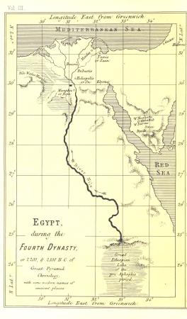
life and work at the great pyramid (1867)
1860s maps of egypt
life and work at the great pyramid (1867)
1860s maps of egypt
life and work at the great pyramid (1867)
maps of the egyptian old kingdom
life and work at the great pyramid (1867)
19th-century maps of the nile river
heimatskunde von leipzig. leitfaden für den unterricht (1867)
old astronomical prints
the hand-book for travellers in italy, from london to naples (1838)
old maps of tuscany
historical
history
life and work at the great pyramid (1867)
life and work at the great pyramid (1867)
frederick henry, prince of orange in engravings
louise de coligny
huis ter kleef in art
1867 in haarlem
historical
history
maps by thomas nast
1872 maps of texas
the web of empire - a diary of the imperial tour of their royal highnesses the duke and duchess of cornwall and york in 1901 (1902)
1901 royal tour of new zealand by duke and duchess of cornwall and york
admiralty charts region u: north america east coast
admiralty charts 201-400
historical
history
an empire story; stories of india and the greater colonies told to children (1908)
1908 maps of india
an empire story; stories of india and the greater colonies told to children (1908)
old maps of canada
an empire story; stories of india and the greater colonies told to children (1908)
old maps of new zealand
an empire story; stories of india and the greater colonies told to children (1908)
1900s maps of south africa
an empire story; stories of india and the greater colonies told to children (1908)
old maps of australia
1858 stamps of sweden
pink stamps
maps of the captaincy general of cuba
maps of the history of florida
géographie illustrée de la france et de ses colonies
géographie illustrée de la france et de ses colonies
géographie illustrée de la france et de ses colonies
orientalist painting
géographie illustrée de la france et de ses colonies
géographie illustrée de la france et de ses colonies
géographie illustrée de la france et de ses colonies
orientalist painting
géographie illustrée de la france et de ses colonies
géographie illustrée de la france et de ses colonies
orientalist painting
géographie illustrée de la france et de ses colonies
géographie illustrée de la france et de ses colonies
géographie illustrée de la france et de ses colonies
orientalist painting
géographie illustrée de la france et de ses colonies
orientalist painting
géographie illustrée de la france et de ses colonies
orientalist painting
géographie illustrée de la france et de ses colonies
géographie illustrée de la france et de ses colonies
orientalist painting
géographie illustrée de la france et de ses colonies
201 - 300 of 310
Next page
/ 4